My goal here is to see if any of the grandchildren of Richard and Addie Dawes would be interested in owning a share of the the patrimony that mom and dad's five children inherited. As farm boys there, Jim and I milked a cow, installed fences, and tended numerous farm animals: chickens, ducks, goats, hogs, a dairy cow, and a couple dozen beef cattle. We had two horses a mule, barn cats, and three dogs. We showed trios of exotic chickens at the Parish and State fairs to earn spending money. Later, Dad added a little Mexican Burro to delight the grandkids. Jim, Mary, and I lived there for a few years. Dottie and Maurice visited, and many of the older grandchildren.
The Project Farms were built for former tenant farmers in 1939, on sugar plantations that failed during the depression. Dad bought one seven years later, after WWII, for about $5,000. He had always wanted to have a farm, and put together a small herd of beef cows.
This is the exact style of the house when we moved in. Grandfather Charles Umbach visited from South Dakota, and closed in the back porch to make a larger kitchen. He turned the front porch into a bedroom for the boys. Not showing is the privy. Dad had the house wired for electricity, and added plumbing for an indoor toilet and shower. The fence posts look like recycled cross ties, which we also used. Look for the boys and dogs around the porch.
The farm is a 10 minute walk to the Southern Pacific railway station. Dad worked in the Railway Mail Service, sorting mail from New Orleans to Houston and back. He could easily 'deadhead' into New Orleans to the Southern Pacific (now Amtrak) terminal. Mom could hand him sandwiches when the train stopped at the station! Dad used his GI Bill to earn a law degree at Tulane. Later he would sell the farm and animals, buy a house near the post office, and practice law. He developed Broadway Commercial Park on the farm land.
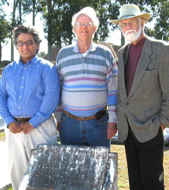
Flash ahead 60 years: Lee, Jim, and I went to Schriever on Nov 4, 2010 to see the land. We also visited the tombs of Richard, Addie, and Addie's mother, Mary Elizabeth Cassidy. Here are pictures showing the tombs in St. Bridget's cemetery:
Lee Chawla, Jim and Reggie Dawes at the tomb of grandma
"Momma K", Mary Elizabeth Cassidy.
Click twice to read the inscription on the tombstone.
Nonnie and Mampaw's tombs.
Here's a link to the Google Map of Dad's farm property. Note the airport and the Amtrak station.
Below is the Google earth map with features marked:
- Dawes Acres... my best guess about the boundaries. We may be ordering a survey soon. The land measures about two acres, or two football-fields.
- The Project House, where Richard and Addie lived for many years. Their kids and all but the youngest of their grandkids visited there. Jim, Mary, and I lived there for 2 to 4 years.
- Locations of Airport and Amtrack stations, less than a mile away.
- Location of a Southern Pacific siding is also marked.
Maps show that the elevation is 14 feet above sea level. The ground is level, and surface drainage seems adequate. Someone is cutting the grass and making hay on the property: it is surrounded on three sides with big cylindrical hay bales.
What should be done with this property? The back neighbor, Harry Bourg, was there. I asked him what he'd like to see there, and he said a vacant lot! I'll ask you all to help brainstorm with me. Enter your ideas in the Comment section below, or contact me by email or telephone, 504-322-4703.
- Current use: a hayfield. This costs nothing to us and keeps the property from sprouting brush.
- Timber. We have already talked about planting some Cypress trees to mark the corners. The Bald Cypress could be quite a memorial. It is hurricane proof; it can live for over 1,000 years. Wood from old growth cypress is called "the wood eternal". It never rots. I'd like my ashes planted under my own cypress tree!

The combined lots were estimated as worth about $50,000 when the estate was settled, 20+ years ago. A recent appraisal set a value of $80,000. If I were to leave an equal share of my 1/5th share to each of my seven children, each would get a 1/35 share, around $2,200.
Dad apparently reserved this choice location for his kids. It may not matter to Richard and Addie any more, but I would like to see it (1) be an asset to the residents and neighbors, like a park. (2) A fitting memorial to Richard and Addie. (3) A refuge for family, if much of south Louisiana goes under water, in 30 or 100 years.
What if the water level rises and low-lying areas like New Orleans go under? The farm is close to Bayou Terrebonne, which at one time carried silt-laden water from the Mississippi. When it flooded, it built up the high ground... about 14 feet on this lot. In 50 years or so, one might be able to drive (or, if there's no gas) ride a mule or bike from Baton Rouge. It would be about a 6 hour ride on a bicycle. The land has supported truck farms in the past. Cattle and mules can survive on grass and hay. Farmers, hunters, and fishermen are everywhere, mostly Cajuns.
I'd like to hear from all of Richard and Addie's grandchildren on this. Do you want the money, or the land? Please email me at land@dawesbiz.net or telephone me (504-322-4703). You might add a comment below. All comments are moderated.


